Warning: This post is splendifferously long.
A trip to South Korea is not complete without encountering some North Koreans and seeing some military right? One thing I found out about South Korea is that they have compulsory military service for all males. Within 4 years after graduating high school, they serve for 22 months in the military. It was surprising because you see the military all over. Their uniforms are almost identical to the US military (go figure) as well. US military is also a strong presence in Seoul and the surrounding areas (28,500 soldiers in South Korea).

I took a tour that went to the DMZ as well as the 3rd infiltration tunnel. It was kind of pricey, but when else am I going to be on the border of two nations that are extraordinarily hostile to each other? Hopefully never. The tour guide told us to take pictures and look at the North Korean side of the river (the river divides the two). The North Korean side has absolutely no trees on any of the hills. Being a starving nation that also has limited natural resources for heating, they have long since chopped down nearly all of the trees in the surrounding ares. It is like a barren wasteland.

A fancy diorama that gives you an idea of how the DMZ is laid out. The Korean war never actually ended, but there is an armistice that has been in effect for the last 59 years. Because the nations are still at war, they have established a line that divides the entities and a zone on either side of the line in which there is no military presence (hence the name of the Demilitarized Zone, DMZ for short). The red line you see is the Military Demarcation Line which officially separates North and South Korea. The yellow is the boundaries of the DMZ.

North Korea (who in essence are real tools about this whole armistice thing) has dug tunnels under the DMZ into South Korea for the purpose of a sneak attack. South Korea has found 4 tunnels thus far, but they estimate that there are as many as 20 more that they don't know about. The 3rd tunnel is the one I visited. It is called the 3rd tunnel because they found it 3rd (creative naming right there). It is only 27 miles north of Seoul and they estimate that 30,000 men per hour could pass through it per hour.
This sculpture is calling for the unification of Korea into one nation again.
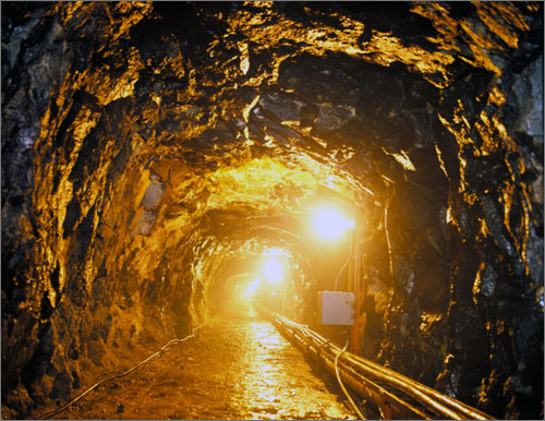
They don't let you take pictures in the tunnel. Someone had taken a picture, and this is exactly what it looks like. You can see that the tunnel is dug out of solid granite. The blast marks and the angle of the tunnel prove that it was blasted from the North Korean side (they point this out because the North Koreans claim the South Koreans built the tunnel). They have you wear hardhats down in the tunnel, which I thought was initially just a sign of being overcautious. After going through the tunnel, I realized that they are absolutely necessary. I stopped counting after the 25th time I whacked my head on solid rock or on a pipe. The problem was that the tunnel wasn't tall enough for me to look where I was going without hitting my head. It was not pleasant.
What was at the end of the tunnel? A wall with a window in it. Beyond that was a minefield and some floodlights and another wall. These are all to discourage the North Koreans from using the tunnel in the future.
What was at the end of the tunnel? A wall with a window in it. Beyond that was a minefield and some floodlights and another wall. These are all to discourage the North Koreans from using the tunnel in the future.

Also at the tunnel they had this big soccer ball. Evidently the soccer ball was a trophy or commemerative trinket of some sort. Where did they put it? In between the bathrooms. Apparently South Korea doesn't like soccer.

There was also this...so...yeah.

On a hill looking over into North Korea they built an observation post. I was standing on the line where you can take pictures. You aren't allowed to take them after this point. I think the reason is so that you don't inadvertently photograph South Korean military placements and stuff.

After the observation post, we went to the train station built 10 years ago to access the North. They say that it is not the last station in the South, but the first to the North. They have connected the tracks that run into North Korea, but it is very rarely used. They built it big enough so that when unification happens, they will be ready to roll.

It was a little spooky because there was no one around, and it was all just sitting there. It felt a little post apocalyptic.

George W. Bush was there for the opening and donated a railroad tie to the station. This is the plaque with the text of his speech.

A sign talking about it being the first station to the north.

Here you could take pictures with the ROK (Republic of Korea) soldiers.

The platform to Pyongyang.

Through some doors they have a big luggage area and facilities for large volume.

We went to lunch at a Korean restaurant just outside of the DMZ. I was excited that there were chairs!

Unfortunately I ended up sitting on the floor. The food was really good though. We had bulgogi. It was like a hot pot of tasty stuff.

After lunch we went to the tourist park near the DMZ. This picture is of the shrine built for people to worship their ancestors whose graves are still in North Korea.

I don't know why I took this picture.

This train was one of the first things hit by the North Koreans. There are over 1000 bullet holes in it.

It stopped working obviously, and was left there.

A fence with all sorts of security measures. There are tags that have to be changed by patrols, stacks of stones that are impossible to reset if they fall, and rocks that are stuck in the fence that will fall if the fence is cut or too much force is exerted.

Ah...the coup de grâce. This pictures is inside the UN meeting rooms on the Military Demarcation Line. You can see an ROK soldier standing at the end of the table. This table precisely divides North and South Korea. The microphones and flag on the table is the midpoint of the line. In this picture, I am standing in North Korea. Jealous?

This soldier is standing guard in front of the door to North Korea.

Here people are taking pictures from the South Korean side (Suckers! I was in North Korea).

The oddest thing was that they let you take pictures with the soldiers. You were instructed not to touch them or get too close, but you could take pictures with them nonetheless. It was a little odd to be smiling while the soldier is walking the line between two warring countries.

The concrete barrier separates North and South Korea. I am on the North Korean side.

This is taken on the South Korean side looking at the North Korean side. The soldiers you see are South Korean. They are deliberately standing in front of the building. It is a strategery. They block the view of their bodies and make it harder for the North Koreans to shoot them.

I tried to zoom in and take a picture of the North Korean soldier standing at the top of the stairs looking at us with their binoculars.

This picture is weird because I am smiling in a very tense place.
Here is a video. It's just like you are there.

We had to stay in the bus, but this is the marker for a tree that stood in the Joint Security Area of the DMZ. You may ask why they have a marker for a tree, but the marker is actually commemmorating the lives and sacrifice of two US servicemen. You can read all about it here. Long story short, a team of engineers and 2 US army officers went into the JSA to trim a tree which was growing too big to allow for visual contact between the observation posts. They were trimming the tree when some North Koreans started making trouble and saying that they didn't have the authority to be there. The US officer in charge continued doing the task he was assigned and cleared to do which made the North Korean mad and when the US captain turned around, the North Koreans attacked. In the midst of the scuffle, the people retreated, but the 2 US army officers were left behind and beaten to death turn-by-turn by the North Koreans. The camp is now named for the US army captain.
Soon after, nearly 20,000 troops were mobilized during Operation Paul Bunyan while engineers went in and chopped the whole tree down. There was fear of war breaking out anew over this conflict and troops were mobilized to combat that. As usual, the North Koreans said it was the fault of the two dead army officers picking a fight. Sickening.

Right near the monument is the Bridge of No Return. This bridge is where the POW's from both sides of the war were brought. They could choose to go back to their original side, or stay in the country they were being held captive in. The catch was that they would never be allowed to go back. Because of that, this bridge was so named because once you crossed it, you couldn't go back. The posts in the middle mark the line between North and South.
Overall it was tremendously interesting to see. I would highly recommend seeing it if you are ever in the area. A lot of history and a lot of blood for this area. Incidents still happen along the Military Demarcation Line nearly every year. The North Koreans are consistently the aggressors in opening fire on South Korean military. In 2010, a North Korean ship launched a torpedo at a South Korean vessel killing 46 men on board. I tell you that we are lucky to live where we do and in the conditions we do. If the North Koreans decide that they are going to go to full scale war with South Korea again, it will be massively destructive with death tolls in the tens of thousands.
2 comments:
Sobering and very interesting. Thanks for your excellent travelogue on the DMZ.
Scary. I would honestly be scared going into any asian country. Racist? Perhaps. But mostly just scared of crap like that. Reporters go missing every year when they accidentally cross invisible lines! NO thank you.
Post a Comment